

Sean C. Morgan
The Sweet Home Planning Commission, during its regular meeting on Feb. 19, approved an eight-lot subdivision at the north end of Strawberry Ridge Drive, rejecting a plan to leave the cul de sac in the private ownership of the residents.
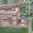
In 2005 or 2006, owner Joe Graybill purchased the land, which sits on the edge of the city’s northwest urban growth boundary and city limits and will be called Strawberry Crest.
Since buying the property, he has considered how he wanted to develop it, and he took inspiration from the property where he grew up on 8th Avenue.
The city’s minimum lot size for low-density residential zones is 8,000 square feet, he said. He grew up on a 12,000-square-foot lot, with a curb and a planter strip.
The lots in the Strawberry Heights area tend to be larger, he said.
“I wanted something that was similar in the look and feel, but I was also looking at something a little more unique. Yes, a standard paved cul de sac is effective – but boring. It sounds to me like I pretty much have to go down the private development route for the street infrastructure if I want to continue with the paver block style.”
Public Works Director Greg Springman urged the Planning Commission to require asphalt or concrete for the street.
The alternative was to make it private, but even still, it would create problems for the city because it is not equipped to replace paver stones when it makes utility repairs.
He said the rest of the citizens of Sweet Home should not be required to pay for those repairs.
Graybill said he was flexible and options exist that could accommodate the paver stones, but he understood the city’s position.
Since Graybill is the city’s staff engineer, Springman and engineering technician Trish Rice filled in for him to complete the Public Works report on the subdivision, to avoid a conflict of interest.
Six residents of the area testified against the proposal and one testified as neutral during a public hearing.
Several raised concerns about drainage and an increase in traffic. One raised concerns that the properties would generally be smaller than surrounding properties and negatively impact local property values.
Another was concerned about the environmental impact to the wooded 2.15-acre parcel, noting the impact of a clearcut at a nearby property on the neighborhood, including an increase in power bills and pests in the area.
Graybill addressed the concerns.
The properties will range from more than 8,000 square feet to more than 11,000 square feet, smaller than many of the properties in the area but exceeding the zoning requirements.
Graybill said the property, which is outside the city limits and zoned farm-forest, to the west of his subdivision was deforested a few years ago by the owner for financial reasons, an example of how property owners are allowed to use their land.
But he prefers having trees, he said. His subdivision will only remove trees that are in the footprints of the houses, and it will require owners to plant additional trees.
Graybill said his project will add catch basins at the end of Strawberry Ridge Drive, where water has been allowed to flow around a curb and sidewalk since the 1980s, causing damage to the curb and sidewalk. According to the owner’s testimony, the house downhill as water drains in sheets across the roadway. The catch basins will capture the runoff.
“That will be renovated and repaired and be done the way it should’ve been in 1980,” Graybill said. Water from the subdivision will be held in detention and allowed to drain out to the city’s storm system slowly.
Among requirements, the subdivision is not allowed to drain excess water from development onto neighboring properties, Graybill said.
Ed Patton of Udell Engineering said that the traffic impact will be negligible, although a couple of residents thought he was underestimating the impact.
Based on national models for traffic, he said the increase in traffic would be less than 20 percent. The area has an estimated 205 trips per day on weekdays. Following development, Patton said, it would have some 243 trips per day.
During Planning Commission discussion, Commissioner Greg Korn said questions were well-asnswered and the proposal looked good.
Commissioner Eva Jurney said the commission answered all of the questions raised by those testifying.
“I understand Joe’s desire to do something different,” Jurney said. “I think practicality overrules the artfulness, so I would be in favor of making that a public right of way.”
She noted that while the subdivision does seem like a dense infill, neither density nor aesthetics are among the criteria the Planning Commission uses to consider a subdivision.
“It looks to me like this is going to help the water problem,” said Commissioner Greg Stephens. “It may not totally get rid of it, but anything that can help is a good thing.”
He and Chairman Lance Gatchell agreed that the cul-de-sac needed to be public right-of-way.
“There are a number of these issues that are just to be expected because we live in an area where we are growing and we’re growing beyond, and it’s one of those things that we deal with,” said Commissioner Henry Wolthuis. “That includes traffic.”
The project is designed “very well,” he said, and “I strongly favor making the cul-de-sac a public street.”
“I think it’s going to be a real plus to the neighborhood up there,” said Commissioner Thomas Herb.
“From what I can see, from the drawings, that area, especially if we can get a curtain drain on the top up there, that’s going to help the neighborhood quite substantially.”
He said he liked Graybill’s idea for paver stones, but he understood the position of city officials.
The commission voted 6-0 to approve the subdivision.
One area resident was concerned that Graybill would have a conflict of interest moving forward.
“The planning office is very cognizant of conflict of interest – and that outside expertise will be engaged to make sure that no impropriety is evident in this,” Jurney said.
Wolthuis said Graybill has taken great lengths to avoid conflict of interest.
Graybill told the commission that he will be involved in handling some permits as the subdivision develops, but by that time, he will not have a financial stake in them.
In other business, the commission approved the partition of two tax lots, totaling 37,917 square feet, into three lots, with the new lots sized at 9,174 square feet, 10,978 square feet and 17,737 square feet.
The property is owned by Floyd Neuschwander and located at 4437 and 4441 Hwy. 20.
Neuschwander said he has no plans to develop the properties further at this time.