


Sean C. Morgan
While other parts of the Willamette Valley suffered from flooding during last week’s torrential rains, Sweet Home has, so far, come through the series of storms relatively unscathed.
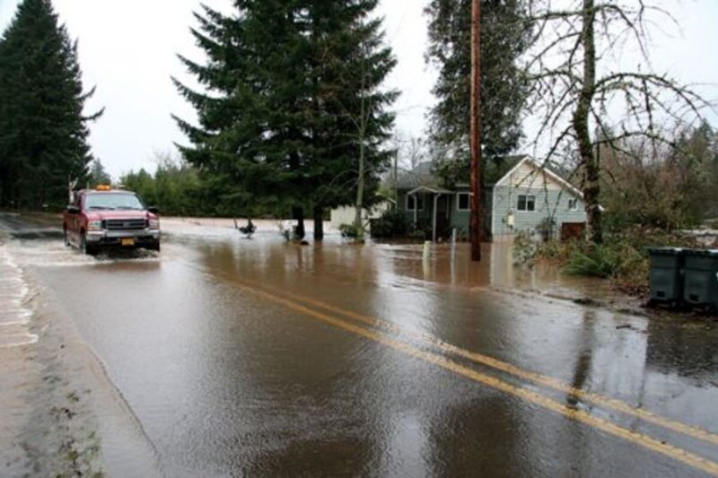
Locally, river levels rose, and some yards and homes on McQueen drive were inundated while water ran across the road. Several houses near the intersection of Highway 228 and Crescent Hill Road became islands as their yards flooded, and a backed-up private culvert flooded Midway Grocery.
A resident on 14th Avenue where Ames Creek typically reaches the home was asking the city government for sandbags, and the city’s Wastewater Treatment Plant began bypassing untreated but heavily diluted wastewater into the South Santiam Thursday afternoon.
Sweet Home schools were delayed two hours and mail deliveries to Sweet Home were delayed two to four hours on Friday.
At 4:13 p.m. on Thursday, the National Weather Service recorded 1.61 and 1.8 inches of rain in 24 hours at two locations in Sweet Home. The U.S. Army Corps of Engineers recorded a combined total of 3.46 inches for Jan. 18 and Jan. 19. Around the valley, rainfall for that period reached 2 to 2.4 inches, while some areas had upward of 4 and even 6 inches of precipitation.
Green Peter Reservoir reached 961.1 feet, 39.1 feet over its minimum pool and 38 percent of its storage capacity, on Friday. Foster Lake was at 640.4 feet, 17.4 feet over minimum pool, with 9,890 cubic feet per second flowing out and 11,712 cubic feet per second flowing into the lake.
On Monday, Foster Lake was at 616.79 feet, while Green Peter was at 973.13.
Several water rescues took place Thursday and Friday in Corvallis, Albany, Jefferson and Salem. Turner experienced significant flooding.
A woman and a child were killed in Albany on Thursday when the vehicle they were in was swept out of the Megafoods parking lot into Periwinkle Creek.
A snow slide covered Highway 20 near Santiam Pass on Thursday. A rock slide blocked one lane just south of Highway 228 on Upper Calapooia Road. Private citizens and a Linn County road crew quickly cleared it.
Central Linn and Corvallis schools closed on Friday. Classes at Linn-Benton Community College and Oregon State University’s main campus were canceled on Friday.
The reason for the high water is mostly evident – heavy rainfall from a strong “pineapple express” storm from the southwest has pounded western Oregon and melted the snowpack, adding to the flood peak. The relentless storm battering western Oregon has created havoc and threatened records – and more rain appears on the horizon.
The Mary’s River reached a record stage, according to Kathie Dello of the Oregon Climate Service at Oregon State University. It reached 21.41 feet Thursday morning, breaking the old record of 20.9 feet, and causing flooding in Corvallis and Philomath.
“Many streams in western Oregon are now classified as ‘high,’ or above the 90th percentile,” Dello said. “What makes this so unusual is that a few days ago, most of these same streams – especially in southwest Oregon – were near record low levels.
“We needed the rain,” she added, “but not all at once.”
The Mary’s River data goes back 72 years for the gauge, according to Gordon Grant, a research hydrologist with the Pacific Northwest Research Station of the U.S. Forest Service.
The rainfall has been significant. On Wednesday, 4.02 inches of rain fell at Hyslop Farm outside of Corvallis – the third highest 24-hour total in the station’s 101-year history. The only other days with more than 4 inches of rain occurred on Nov. 19, 1996 – when massive flooding hit Oregon – with 4.45 inches; and on Jan. 28, 1965, with 4.28 inches.
The Coast Range has been especially hard hit with 5 to 7 inches of rain common in many areas, causing flooding of the rivers draining those hills, including the Siuslaw, Mary’s and Luckiamute rivers.
“We’re getting what is called an ‘atmospheric river’ or ‘pineapple express’ event, with warm, wet weather coming from the southwesterly direction,” Dello said. “These tend to be big rain events here in Oregon, though it is still cold enough at higher elevations to snow in the mountains, which was desperately needed.”
Additional information, as well as links and other weather-related resources are available at the Oregon Climate Service website: http://www.ocs.oregonstate.edu/.
Ryan Beathe, right, of the Linn County Road Department, and Jarred Claunch look at rocks that had fallen on Upper Calapooia Road, near the intersection of Highway 228 (visible in distance) about half an hour earlier on Thursday afternoon. Claunch and Scott Collingwood had cleared the roadway of boulders that had fallen in the left lane.