


Sean C. Morgan
Project team members take field trip to check out the lay of the land
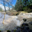
Members of the South Santiam Community Forest project team on Friday spent the day visiting key sites along the proposed corridor, from Sweet Home to Cascadia Cave.
The South Santiam Forest Corridor Project proposes an as-yet undefined corridor along the South Santiam River, from a point that started at a former Knife River (Morse Bros.) gravel site northwest of Clark Mill Road to the Willamette National Forest, east of Cascadia.
It is part of a program created by Gov. John Kitzhaber called Oregon Solutions, which is meant to bring “together public, private and nonprofit stakeholders to leverage resources and integrate programs for sustainable community projects.”
The team’s goal is to “find better ways to ensure public access to natural resources, provide opportunities for nature-based and cultural tourism, improve public health, support jobs, and promote natural resource health both along the river and in the entire South Santiam watershed,” says a team progress report.
The group has formed three subcommittees that will deal with “recreation and tourism, work on Cascadia Cave and cultural resources in the area and look at the area as a working forest – promoting economic opportunity through specialty forest product development.
Linn County-Jamboree Partnership
Linn County Parks and Recreation Director Brian Carroll described plans to develop the former Knife River property as a park, providing public access to the South Santiam River and a permanent home for the Oregon Jamboree country music festival and other events.
The site is located along the south bank of the South Santiam River and features several ponds.
“There is quite a bit of wildlife on this property,” Carroll said. “Geese, osprey, eagles.”
Currently, the county is working with the Jamboree on potential expansion to more than one weekend a year for the festival site, Carroll said, and work is moving forward with Knife River on cleaning up the property.
“We have some ground decontamination to do” before the property is ready for public access, said Linn County Commissioner Will Tucker, who participated in Friday’s outing.
The U.S. Forest Service is applying for a grant to use “biochar,” a charcoal-like material, to help with the cleanup, and Knife River has a bond held by the state to do some work on the site.
“We’re just working on the final details to come in and start the work,” Tucker said. The site has isolated small oil spills, and the county is waiting to learn about potential arsenic contamination, something that plagues other parts of Sweet Home.
Carroll showed members of the tour conceptual plans for developing the property.
“It’s certainly not anything set in stone,” he said. “It’s more or less just an idea.”
Beyond the environmental issues, the county still needs to work out access.
“If you were to hold a concert here, you’d need more access points,” Carroll said. The Jamboree draws some 14,000, and the county is looking at ways to get them into the property, which is accessible only through Clark Mill Road at this point. Other potential access points could include the former Willamette Industries-Weyerhaeuser property to the south.
All of the property is owned by the county after foreclosing at the end of 2010 for nonpayment of property taxes by Western States Land Reliance Trust, which had proposed residential and commercial development.
Moose Creek
The tour stopped on Moose Creek Road to observe a restored dispersed camping area along the South Santiam River. The site is also the location of Camas Prairie, a meadow managed for camas and harvested by members of tribes who are descended from South Santiam Native Americans. The meadow is burned every other year.
Camas was a staple of Native Americans in the area, said Tony Farque, Sweet Home Ranger District archaeologist.
Across the road, near the river, fencing built from downed wood is used to discourage the creation of too many paths to the river banks, said Stefanie Gatchell of the Sweet Home Ranger District. Without them, it encourages the creation of numerous trails. The popular camping site was bare dirt until restoration around 2008.
Nearby is the former site of Triple T Studs, which closed about a decade ago, Carroll said. “It’s been for sale. It’s one of the sites we’ve thought about as a potential acquisition in the corridor.”
Cascadia State Park
At Cascadia State Park, where soda springs and the former site of the
Photo by Sean C. Morgan
GRAND RONDE Elder Don Day and Forest Service archaeologist Tony Farque demonstrate the split plank construction used by Native Americans during a presentation at Cascadia State Park.
Geisendorfer Hotel are located, Farque discussed how Native Americans lived along the South Santiam long before the hotel and Cascadia existed.
Children would gather firewood for the camas ovens, he said. After burning the wood and removing the ashes, a fire would burn on top of the camas for 72 hours.
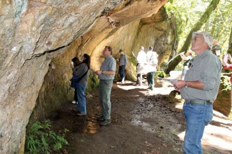
ARCHAEOLOGIST Tony Farque points out petroglyphs at Cascadia Cave while Lisa Chase reflects sunlight into the concave rock structure.
“They come out tasting like a roasted pear,” Farque said. Along a path leading to the nearby Cascadia Cave, Farque pointed out the natural fishing platforms on the South Santiam River and the various plants and trees the Native Americans used in different applications, from making bows and canoes to medicine and food.
Along the trail are two of the oldest trees in the area, one estimated at about 800 years old and the other at 1,200.
The park and cave are near an important historic intersection. The east-west route from the mid-valley to Central Oregon and a north-south road used to reach the trading center at the Willamette Falls near Oregon City. The Molalla Indians, whose descendents are among the Grand Ronde, Siletz and Warm Springs tribes, traded with the Santiam-Calapooia Indians, who tended and processed camas. The Molallas collected berried and traded obsidian from a bluff near the South Sister.
Cascadia Cave
Cascadia Cave is a concave rock face that contains numerous petroglyphs and is an important historical site to the Warm Springs, Siletz and Grand Ronde tribes. Deciphering the meaning of the petroglyphs has been a long process, and remains under discussion.
Visitors sometimes discover new petroglyphs, while some that were noted by previous researchers cannot be found easily today.
A 9-year-old girl on one of numerous school field trips to the cave was the first to notice that all of the petroglyphs, which are predominantly bear paws, appear on a giant outline of a salmon facing east, upstream, Farque said. Both bear and salmon are culturally and spiritually significant to the local tribes.
The cave is on land managed by Cascade Timber Consulting and owned by the Hill family, and discussions are under way about ways to move the land into public ownership, study it more substantially and provide interpretation for visitors. Currently, access to the site is by permission only and visitors who don’t have approval from CTC to be there are technically trespassing.
Some say the cave should be a national monument, Farque said. Others say it should be a state monument, and the tribes believe it should be a world heritage site.
The rock is a volcanic tuff, and the site is fragile, Farque said. The rock is at risk, and visitors should not touch the wall or the large rock in front of it. The tribes and Farque also ask that no one record video at the site, while still photography is permitted. Anyone finding artifacts should leave them at the site, which may be visited as part of organized tours with the Forest Service.
Farque thanked CTC for protecting the site.
Hill Park
Another tour stop was at Hill Park, a 20-acre parcel along the South Santiam, managed by CTC, that includes about 10 acres of 280-year-old trees.
The park is a little east of River Bend County Park between Highway 20 and the river.
CTC cannot do much with the timber, which is located between the highway and river. It’s among parcels that CTC would be interested in swapping for similar parcels CTC could use, said Mike Reynolds of CTC.
River Bend
The final stop on the tour was the 90-acre, 85-site River Bend County Park, part of a parks system that is self-sustaining and the newest Linn County Park.
That’s one of the proposed features of the corridor proposal, Carroll said. The corridor is supposed to be self-supporting. While River Bend may not be a perfect model, it provides an example.