


Sean C. Morgan
Of The New Era
Heavy rain last week, especially Jan. 16 and 17, caused minor flooding throughout the Sweet Home area.
Water filled fields and yards all around Sweet Home, while creeks overflowed their banks to flood pastures.
According to the U.S. Corps of Engineers, which records rainfall levels at Foster Dam, nearly 12 1/2 inches of rain had fallen between Jan. 1 and midnight Saturday, Jan. 21. Last week’s rainfall between Tuesday and Friday alone, 4.14 inches fell at the dam.
Green Peter Lake was approximately 15 feet below full pool on Friday, dam operators said, and the dam continued to be at maximum discharge over the weekend.
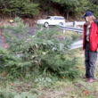
On McQueen Drive, the Calapooia River overflowed through Don Hopkins’ ranch. Debris carried by the rushing water, what Hopkins calls the Calapooia North Fork, smashed down fences and gates.
Hopkins’ fields were covered in dead tree limbs and logs. He even found a Weyerhaeuser sign warning against trespassers.
Hopkins lost some 700 feet of fencing and three gates, he said.
On Crawfordsville Drive, north of Highway 228, a stream rushed across a field and the roadway east of the Scott Mountain turnoff. Just east of the intersection, standing water filled the roadway.
Small streams of water flowed across the road at several points while the Calapooia River rushed around tree trunks on its banks.
In town, the home of Darla Jaques avoided its usual assault from Ames Creek during heavy rain and flooding. The home is located at the 14th Avenue bridge over Ames Creek. In 1996, water rushing down Ames Creek crashed against the corner of the home.
Water started rising in Ames Creek on Jan. 16, Robby Jaques, Darla’s son, said. By morning, it was reaching toward the house.
Darla contacted the city of Sweet Home for help, and City Manager Craig Martin, Mayor Craig Fentiman and Public Works Director Mike Adams went to the rescue. The city provided sandbags and sand, and Robby put up boards and sandbags to hold the water out.
His efforts appeared to pay off. The water behind the boards and sandbags was still, although it did reach several inches up the foundation. In the backyard, water reached Robby’s knees along the bank.
Robby was mostly concerned the afternoon of Jan. 17 about trees along the bank falling and the bank eroding along the front yard.
Green Peter Lake was above its normal level last week, reaching 993.77 feet on Friday, Jan. 13. Summer pool is at 1,001.1 feet. Foster Lake remains at winter pool.
The U.S. Army Corps of Engineers was storing as much water as possible in its Willamette Basin dams to protect against flooding.
Fern Ridge Reservoir was about one foot from full pool on Jan. 19.
The Corps warned that rivers will continue to flow high while it continues releasing water from its reservoirs between storms to provide more flood control space in the reservoirs.
When the next storm arrives, the Corps will reduce releases, if possible, and store water to reduce downstream impacts.
With storms occurring in rapid succession in the last four to six weeks, without adequate time in between to diminish reservoir storage effectively, the already complex job of managing water in the reservoirs becomes even more complicated, said Erik Peterson, operations manager for the Willamette Valley Projects. The Corps will evaluate and adjust releases hourly.
Downstream river levels on the South Santiam River at Jefferson were reduced by five feet with regulation of Green Peter and Foster dams.
On the Willamette River, at Eugene, Salem and Oregon City, river levels would have been 12.8 feet, 7 feet and 3 feet higher respectively without dam control.
The 13 dams in the Willamette Valley control runoff from 27 percent of the entire basin.