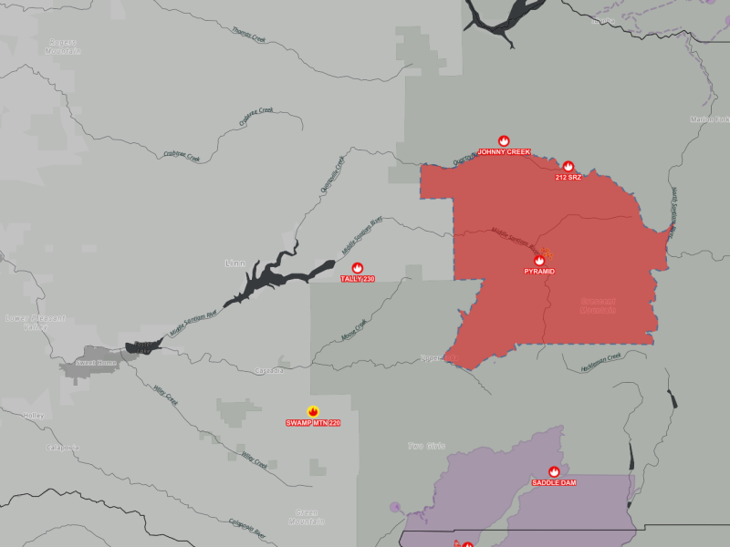
Aug. 28, 2024. The Willamette National Forest has reduced the emergency closure order issued for the Pyramid Fire, which was reported July 17 in the Sweet Home Ranger District. The closure order rescinds order 06-18-03-24-30 and is effective Aug. 28, 2024, through Nov. 15, 2024, unless modified or rescinded sooner.
The lightning-caused Pyramid Fire, located east of Sweet Home, is approximately 1,312 acres in size and 98% contained.
Recreation sites now open include Crescent Mountain Trail #3384, North Pyramid Trail #3383, Pyramids Trail #3380, and Scar Mountain Trail #3402, Big Springs Sno Park, Coffin Mountain Trailhead, Crescent Mountain Trailhead, Daly Lake Day Use/Campground, Maxwell Butte Sno Park, Lava Lake, North Pyramid Trailhead, and Pyramids Trailhead. All roads and trails serving as the closure boundary, such as FSR-11 and the North Pyramid Trail, are open for travelers.
Trails and recreation sites that remain closed include Bridge to Nowhere Trail #3377 and Trailhead, Chimney Peak (Shedd Camp) Trail #3382 and Trailhead, Gordan Peak Trail #3387 and Trailhead, McQuade Creek Trail #3397 and Trailhead, Parish Lake Trail #3383 and Trailhead, Pyramids Bypass Loop #3376, Riggs Lake Trail #3388 and Trailhead, Swamp Peak Trail #3401 and Trailhead, South Pyramid Creek (west of Cresent Mountain Trail #3403) Trail and Trailhead, Blowout Bridge Trailhead, Middle Santiam Wilderness, Scar Trailhead, and South Pyramid Horse Campground.
For a map of the closure area and a complete list of recreation sites and roads included in the order, visit our website at https://www.fs.usda.gov/alerts/willamette/alerts-notices.
Please be aware of current restrictions before you head out into the forest and share information with others. As fire restrictions change, information will be available at https://www.fs.usda.gov/main/willamette/fire.
Update: Aug. 26, 8:20 a.m.
1,312 acres, 98% contained, 221 total personnel, lightning caused.
Recent moisture has helped heavy equipment operators working on grading and improving roads. Roadside fuel hauling and brush chipping
is ongoing, and crews continue to secure containment lines and fortify outlying contingency lines. Firefighters continue to strengthen existing fire breaks along roads by removing brush and smaller trees.
Update: Aug. 15, 9 a.m.
1,323 Acres, 73% Contained, 223 Total Personnel
Crews and heavy equipment continue to hold and improve fire lines, patrol the fire perimeter, and conduct mop up. Pockets of intense and scattered heat continue to be identified by infrared technology.
Update, Aug. 12, 9:20 a.m.
1,324 Acres, 64% Contained, 292 Total Personnel
The established fire perimeter continues to hold, with pockets of intense and scattered heat identified by infrared across the fire. Today, crews will continue holding and improving line, mopping up and extinguishing hot spots.
Update, Aug. 6, 9 a.m.
Current Situation: The Pyramid and Slate Fires are being managed by Rocky Mountain CIMT1. On Wednesday, Aug. 7, California Interagency Incident Management Team 13 will assume management of the Pyramid and Slate fires as well as the Ore Fire.
1,328 acres, 31% contained
Division B/E: Crews continued with strategic firing operations yesterday to bring the fire edge to indirect control lines and secure the fire perimeter. Sprinkler systems have been installed and are operating. Firefighters are patrolling and securing the fire perimeter where needed.
Division Y: Yesterday, firefighters constructed a combination of direct and indirect handline. Today, they will continue to focus on constructing direct line and removing standing dead trees to hold and secure the fire perimeter.
Update, Aug. 5, 8:45 a.m.
The Pyramid and Slate Fires are two of 10 fires currently being managed by Rocky Mountain Complex Incident Management Team 1, all of which are on the Willamette National Forest. A full suppression strategy is being implemented for both the Pyramid and Slate Fires.
Pyramid Fire (1,296 acres, 31% contained)
Division B/E: Crews were able to conduct strategic firing operations again yesterday to bring the fire to indirect control lines. Crews will use strategic firing operations again today if conditions allow and continue efforts to secure the fire perimeter.
Division Y: Yesterday, firefighters finished removing standing dead trees and constructing indirect control line around one of last week’s spot fires. Priorities will continue to be to secure the fire’s perimeter.
Slate Fire (91 acres, 99% contained)
Crews continued to patrol and secure the fire perimeter and began removing logs cut during construction of indirect control lines. Firefighters remain focused on mopping up and adding control line depth.
Saturday, Aug. 3: 1,260 acres, 31% contained
Divisions B and E: On Saturday (Aug. 3), crews conducted strategic firing operations in several areas to slowly bring fire to indirect containment lines and ensure the fire is contained within the control line perimeter. Crews will continue to use strategic firing operations today as weather allows and will patrol and secure control lines.
Division Y: Firefighters focused on removing standing dead trees and constructing indirect control line around one of last week’s spot fires to secure the fire perimeter. They also constructed direct control line where it was safe to do so. Priorities will continue to be to construct direct and indirect control line and secure the fire’s perimeter.
Update, Aug. 2, 8:30 a.m.
1,193 acres, 21% contained, 448 total personnel
Yesterday, firefighters continued to hold the fire within control lines with help from water-dropping aircraft. Today, hand crews will continue to widen and improve control lines, construct control lines closer to the fire’s edge where it is safe to do so, install pumps and hoses, and extinguish hot spots.
Update, July 29, 8:30 a.m.
Willamette National Forest reported the Pyramid Fire is at 1,125 acres with 9% contained.
Yesterday, an inversion trapped smoke and cooler air near the ground, reducing fire activity and allowing firefighters to make good progress improving control lines. Heavy equipment was used to improve Road 646, and hand crews on the south flank installed additional hose and pumps to reinforce existing control lines. Today, crews will continue to improve existing control lines, look for opportunities to construct direct line, and insert additional hose and pumps on the fire’s edge to help extinguish the fire.
—
Update, July 25, 8:30 a.m. : Willamette National Forest reported the Pyramid Fire, located east of Middle Santiam Wilderness, is now 615 acres with zero percent containment.
Crews used dozers, masticators, heavy equipment and hand crews to open existing roads and clear vegetation in order to establish a good control line around the fire. In the afternoon on July 24, west winds increased fire activity and caused a three- to five- acre spot fire on the southeast flank. Fire crews surrounded the new spot and, using hose and pumps, worked to extinguish it. Today, crews on the east and west flanks will continue working to complete the control line around the fire’s perimeter.
—
Update, July 21, 9:34 a.m.: Willamette National Forest reported the Pyramid Fire is approximately 500 acres in size and this morning at 6:00 AM, California Interagency Incident Management Team 5 assumed command of the Pyramid Fire. The fire is burning in old-growth forests with heavy timber and steep rugged terrain, making access difficult for firefighters. Crews have been constructing indirect containment lines using heavy equipment, opening up old roads, and clearing trails in an effort to keep the fire from spreading into the Middle Santiam Wilderness, private industrial timberlands, and communities. The fire is being managed under a full suppression strategy, and the team has ordered more resources and equipment to battle the fire while always keeping firefighter safety in mind.
A Red Flag warning is in effect until this evening for scattered thunderstorms, lightning, and critically dry fuels. Gusty outflow winds may increase fire activity throughout this period.
—
Update, July 19, 5:40 p.m.: Willamette National Forest reported the Pyramid Fire is approximately 300 acres in size and the official cause has been determined to be from lightning.
Closed campgrounds and recreation sites include Big Springs Snow Park, Daly Lake Day Use and Campground, Maxwell Butte Snow Park, Middle Santiam Wilderness, and South Pyramid Horse Camp.
Closed trails include Bridge to Nowhere #3377, Chimney Peak (Shedd Camp) #3382, Crescent Mountain #3384, Daly Lake #3385, Gordan Peak #3387, McQuade Creek #3397, North Pyramid #4161, Parish Lake #3383, Pyramids #3380, Pyramids Bypass Loop #3376, Riggs Lake #3388, Scar Mountain #3402, South Pyramid Creek #3403, and Swamp Peak #3401.
Closed trailheads include Bridge to Nowhere Trailhead, Chimney Peak (Shedd Camp) Trailhead, Crescent Mountain Trailhead, Gordan Peak Trailhead, Maxwell Butte Trailhead, McQuade Creek Trailhead, North Pyramid Trailhead, Parish Lake Trailhead, Pyramids Trailhead, Pyramids Bypass Loop Connector Trail, Riggs Lake Trailhead, Scar Mountain Trailhead, South Pyramid Creek Trailhead, and Swamp Peak Trailhead.
For a map of the closure area and a complete list of recreation sites and roads included in the order, visit our website at https://www.fs.usda.gov/alerts/willamette/alerts-notices.
Please be aware of current restrictions before you head out into the forest and share information with others. As fire restrictions change, information will be available at https://www.fs.usda.gov/main/willamette/fire.
—
July 18, 2024
What began as a three acre fire has quickly expanded to 60 acres, forcing a LEVEL 3: GO NOW! Evacuation Alert east of Sweet Home, approximately 19.4 miles east of Green Peter Dam.
Reports indicate the “Pyramid Fire” was discovered at 12:26 p.m. on Wednesday, July 17. The evacuation alert, coordinated with the United States Forest Service, is issued for a large area in the Sweet Home Ranger District, but LCSO Sheriff Michelle Duncan said there are no residential structures in the area that are in jeopardy of the fire.
The LEVEL 3: GO NOW! Evacuation Alert means all roads, hiking trails, campgrounds, lakes and recreational areas within the evacuation boundary are closed. This includes Soda Fork and Sheep Creek areas over to Lava Lake. The fire appears to be merging into the Johnny Creek and 212 SRZ fires to its north.
The public should not enter the evacuation area. Emergency crews and response vehicles will be heavily present, and public traffic can hinder their efforts to fight the fire. Sheriff Duncan said the fire itself is much smaller than the evacuation area, but the large evacuation area allows wildfire response teams enough space to safely travel and fight the fire.
For more information, people can refer to the Linn County Fire Map (https://tinyurl.com/LinnCoFireMap) for full details of the issued evacuation area in red.
The following links and sites should be reviewed by recreationists before heading out:
Linn County Sheriff’s Office Fire Evacuation & Status Live Updates – https://www.linnsheriff.org/wildfire_live_updates/
Linn County Sheriff’s Office Wildfire Preparedness & Resources – https://www.linnsheriff.org/wildfire-recovery/
Linn County Wildfire Map – https://tinyurl.com/LinnCoFireMap
State of Oregon Fires and Hotspots Dashboard – https://experience.arcgis.com/…/6329d5e4e13748b9b9f7f3…/
U.S. Forest Service – Willamette National Forest – https://www.facebook.com/willamettenf
and https://www.fs.usda.gov/main/willamette/
Oregon Wildfire Response & Recovery – https://wildfire.oregon.gov
Oregon Air Quality and Smoke Information Map – https://www.oregonsmoke.org