


Sean C. Morgan
The tip of Green Peter is a narrow ridge of rocks shared between antennae structures and Green Peter Lookout.
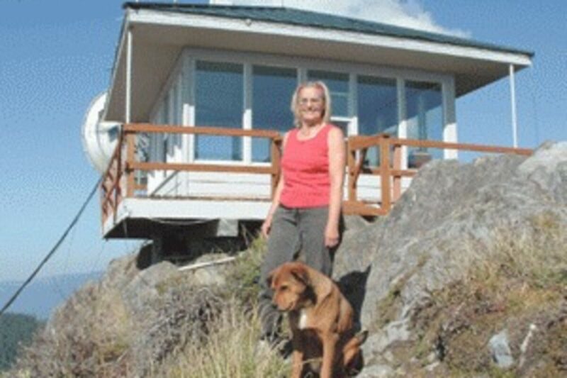
The lookout station sits precariously on the ridge, two sides overhanging the edges at an elevation of 3,977 feet. A road that gets steeper the closer it gets to the top is used to reach the lookout. The edge of the roadways are steep slopes.
The last bit can barely be considered a road. Forest Protection Supervisor for Jim Basting, Oregon Department of Forestry Sweet Home Unit, drives up to the look out, he pulls out to a point then backs up the hill just below the lookout. When he leaves, he pulls forward to the tip of the point and backs down the road a short ways where he can turn around.
The lookout, Jane Strom, parks a little lower and hikes up a different path to reach the station.
From the lookout, the land around Sweet Home looks like a Forest Service map in relief. Green Peter and Foster reservoirs are easily identified landmarks. Nearby is Bald Peter, and just below Mt. Jefferson, Coffin Mountain is visible more than 17 miles away. Three Sisters, Mt. Washington and Three-Fingered Jack are all clear, and to the north, just to the left of the tip of Mt. Hood, Strom and Basting have been watching some kind of communications tower go up.
Inside the lookout, Strom has attached strips of paper along the top of the walls. She is drawing a picture of the landscape visible through 360 degrees of windows with the names of the many ridges, peaks and other landmarks to help identify them quickly.
Sweet Home Unit recently finished painting and remodeling the lookout station.
The first lookout on Green Peter was built in 1920. A photo hanging in the Sweet Home Unit office shows former Linn County Commissioner Dave Schmidt in the doorway. The lookout was demolished and rebuild with materials from Jordan and one other lookout in 1970.
Sweet Home Unit added a new catwalk and rail with new paint and new windows.
The lookout has been continually manned since 1920, with the exception of two summers, Basting said.
The lookout is in the National Historic Lookout Register, a registry recognizing fire lookout sites, structures and towers with historic and cultural significance to forest fire detection and promoting their protection.
For decades, lookouts dotted the forest landscape, Basting said. In the early part of the 20th century, firefighters would often spot smoke, chase it down and fight fires alone or in small crews, camping out at the fire until it was beaten. Messages were often written and hand-carried between firefighters.
At one time, the Linn County Fire Patrol had 10 lookouts, including two in the North Santiam Canyon.
In 1969, “they started the helicopter program for patrol, kind of the start of the demise of the lookouts for our district,” Basting said. Over the next several years, unfortunately, forest firefighters burned down many of the lookouts.
The helicopter patrol ended by 1980, Basting said.
In the Oregon Department of Forestry, Basting believes Green Peter is the only lookout still in use. The U.S. Forest Service operates a look out on Coffin Mountain, which is visible to Green Peter. Lookouts are more common in Southern Oregon and Central Oregon.
The Department of Forestry will use a fixed-wing aircraft following big lightning storms or during extreme fire danger, but most of the time, ground patrols and the lookout keep an eye out for smoke.
At the lookout, “on a clear day, you can see a lot of stuff,” Basting said. It is easy to pick out illegal burns and lightning strikes. One of Strom’s most recent significant catches was finding where someone had shot an insulator off a power line.
Saturday, she spotted a number of illegal burns with the lifting of the burn ban. Saturday was not a burn day, and persons still need permits to burn until the official end of fire season.
“Quite frankly, it’s a peace of mind to know she can see everything up there,” Basting said. Between the Forest Service lookout in the Detroit District and Green Peter, they can see most of the Quartzville Corridor.
Strom has been working at the lookout for five years. She first worked as a lookout at age 21, some 42 years ago. In those days, she was on 24 hours per day, seven days a week at Tom Rock Lookout, one Basting helped burn in the mid-1970s. Now, she works eight hours a day with a couple of days off in the middle of the week, though she does spend the night sometimes.
It’s a peaceful, beautiful place,” Strom said. “I remember thinking, I’ve never had a job like this. It was pleasant. I know I can do it. I don’t mind being alone.”
She enjoys being at the lookout, “the quiet, calm and peacefulness,” Strom said. “It’s breathtaking.”
It also gives her a chance to do “things ordinarily I would not take the time to do at home,” Strom said.
Strom continues as lookout “until Jim says, ‘Jane, you can leave now,'” at the end of fire season.
“Every time I come up here, she’s got some kind of project going,” Basting said.
Usually, Strom scans the landscape every 15 minutes or so. In between, she has canned blackberry jam and then wondered why thinking about how she was going to pack it out. She paints, draws, reads and listens to the radio.
If she spots smoke, often just a wisp, she uses her fire finder to pinpoint the direction to the fire. She tries to pinpoint how far out the fire is from the lookout using a map on the fire finder and comparing it to landmarks around it.
She reports that information to a dispatcher, and fire patrols and firefighters respond.
The fire finder has a device that turns 360 degrees. The user looks through a slot, turning the disc-like shape until crosshairs are centered on the smoke, providing a precise direction to the fire. Where they exist, multiple lookouts can triangulate the exact location of a fire using that information.
Spotting fires and the difference between smoke and fog gets easier after practice, Strom said. She picked out one that was difficult to see through the haze toward Lacomb and another small one in the Scott Mountain area, both likely illegal burns and barely visible.